By Bill Verbeten, Regional Agronomist, Cornell Cooperative Extension
There’s a lot of excitement and uncertainty about farm ‘drones’. These unmanned aerial systems (UAS) have a lot of potential to improve crop management and we are getting a lot of questions about their use in western NY.
Drone, UAV, UAS?
What does it all mean? Many people think of the large military craft when they hear the word “drone” and know that it’s an aircraft without an on - board pilot. However, many smaller unmanned aerial vehicles (UAVs) have become common. An unmanned aerial system (UAS) includes the UAV, the ground control station (what is used to fly the UAV), the pilot, a visual observer and any other needed equipment. Our UAS, purchased from PrecisionHawk , is pictured in Figure 1
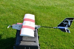
Figure 1
Can I legally fly a UAS over my farm?
It depends how you use it. As long as you fly your UAS under 400 ft, are more than 5 miles away from the nearest airport, fly only during daylight hours, obey visual flight rules, and do not use the UAS imagery to make a management decision on your crops or livestock then as a hobbyist you would be in compliance. However if you use the UAS imagery to, for example, write a prescription for variable rate nitrogen on corn, even if it’s fed to animals, you would be in violation of the law. A change in management = commercial UAS use. We have obtained FAA approval to conduct research on a small number of farms in western NY to evaluate management changes based on UAS imagery beginning in 2015
How can I get a usable picture of my field from UAS imagery?
Software that stiches images together is needed to make a usable mosaic from UAS imagery. Many farmers in other parts of the US and Canada have spent a lot of time trying to figure this out with varying degrees of success. Paying for a service that does this automatically can save a lot of time if you don’t have the expertise. We using PrecisionHawk’s Datamapper service to get us and our collaborators useable geo - referenced imagery that can be taken back to the field within 24 hours of scanning with our UAS. Open source tools like TileMill hosted by Mapbox are also available
What would I have to do to legally fly a UAS for eventual commercial use?
The proposed commercial UAS rules will likely be released for public comment in early 2015. While a number of things are up in the air, two things are going to be part of the process to legally operate UAS: a second class aviation physical and passing the private pilot written exam for airplanes (fixed - wing UAS) or rotorcraft (quadcopter UAS). Pilot training will be similar to getting a CDL, pesticide applicators license, or CCA certification. The more we can self - educate and self - regulate the better off we will be as an industry. There are a lot of rules in the sky and a lot of knowledge about flying
Source:cornell.edu
Click here to see more...