By Eric Hamilton
Severe wildfires have become annual events in the United States. The years 2020 and 2021 were the worst in wildfire history in California. Other states – and countries – are at risk as well. Climate change is making wildfires more likely in some places. And with heavy populations residing in areas bordering wildlands and forests, many people are more likely to experience serious wildfires.
“Better understanding and prediction of wildfire danger is increasingly important. The area burned annually by wildfires in the U.S. has more than tripled in the past 40 years. Similar trends are occurring in other parts of the world,” says Tyson Ochsner, professor of plant and soil sciences at Oklahoma State University. Ochsner studies how to apply soil science to other fields.
Ochsner and his colleagues Erik Krueger and Matt Levi have partnered with the U.S. Forest Service to research how soil science can improve wildfire predictions. Ochsner recently presented their work at the 2022 ASA-CSSA-SSSA annual meeting, held in Baltimore, Maryland.
Right now, most experts rely on weather data to predict wildfires. If an area is in a drought, for example, the risk goes up. But Ochsner’s group has revealed that soil data can make these predictions better.
“Over the past decade or so, researchers have learned that soil moisture information can contribute to better wildfire danger ratings in many locations by replacing outdated drought indices and by informing predictions of fuel moisture and fuel loads,” Ochsner says.
This evidence has rolled in from forests in California and several countries, including Canada, Australia, China, and Thailand. Soil moisture also affects the likelihood of grassland fires. These fires occur in many areas that are not forested. Low soil moisture causes plants to stop growing and dry out, which provides fuel for a fire.
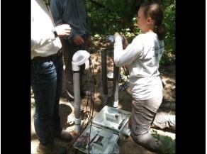
Unfortunately, soil data is much harder to come by than weather data. Decades of work resulted in weather station networks and satellites that can track weather conditions all over Earth. Soil monitoring is much more limited, and even though satellites can also help measure soil conditions, they have limitations.
“One major challenge is that we do not have adequate soil moisture observations in forests. They have few monitoring stations on the ground and the satellites we use to observe soil moisture from space can have difficulty penetrating the forest canopy,” Ochsner says.
One way to make up for limited data is to develop computer models to extend the data that exists to new areas. Zack Holden and his team at the Forest Service developed one such model. Called TOPOFIRE, it shows potential to improve soil moisture predictions across the country, including in hillier regions.
Click here to see more...