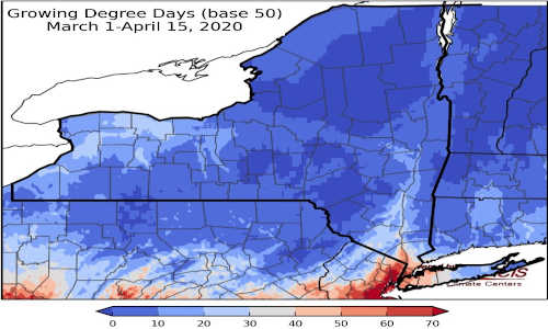
Last week temperatures ranged from near normal to 4 degrees below normal. Precipitation has ranged from a quarter of an inch to near 3 inches. Base 50 growing degree-days ranged from 0-10.

Today temperatures will be in the mid 30s to mid 40 with light snow showers continuing behind a front. Overnight lows will be in the 20s.
Friday temperatures will be in the 30s to mid 40s; the next system will move in in the afternoon bringing rain and snow. Some areas could see accumulating snow, depending on temperatures and how far north the system moves. Overnight temperatures will be in the mid 20s to mid 30s with additional snowfall expected.
Saturday temperatures will be in the mid 40s to near 50 with clearing conditions. Overnight temperatures will be in the mid to upper 30s.
Sunday highs will be in the 50s with showers possible late in the day into Monday. Overnight temperatures will be in the mid to upper 30s.
Monday temperatures will be in the mid 40s to upper 50s with dry weather. Overnight temperatures will be in the mid 20s to mid 30s with precipitation ossible again overnight into Tuesday.
Tuesday highs will be in the mid 40s to mid 50s with showers possible as a cold front passes. Overnight temperatures will be in the 30s.
Wednesday highs will be in the 50s with mostly dry weather. Overnight temperatures will be in the 30s.
The seven-day precipitation amounts will range from a tenth of an inch to three quarters of an inch.
The 8-14 day outlook (April 23-29) slightly favors below-normal temperatures for most of the state. Above-normal precipitation is slightly favored for most areas.
Source : cornell.edu