Farms.com Home   Ag Industry News

Weather alert issued by Environment Canada

Heavy rain on the way

By Diego Flammini, Farms.com

Environment Canada has issued a weather alert for the Greater Toronto Area, Haldimand, Hamilton, Peel, Dufferin, Bancroft, Barrie and other areas.

Heavy rain, as much as 50mm in some areas could fall by the time Tuesday evening rolls around.

“A cold front moving through Southern Ontario today will generate showers and isolated thunderstorms,” the statement says. “With a very moist air mass in place, these showers and thunderstorms could produce local amounts of 30 to 40mm by this evening.”

Heavy rain on a farm

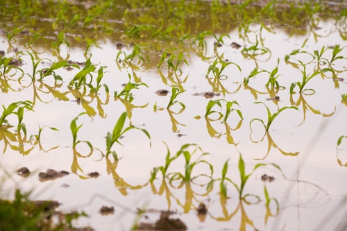
For farmers, heavy rain could damage crops, impact yield and make it difficult to even get into the field.

According to the Farmers’ Almanac, the weather for Ontario is right on schedule:

  • July 4th to 7th – Severe thunderstorms, in the Great Lakes Region
  • July 8th to 11th – Showers and thunderstorms, then fair
  • July 12th to 15th – More thunderstorms
  • July 16th to 19th – Hot, dry weather (32°C to 34°C)
  • July 20th to 23rd – Fair skies
  • July 24th to 27th – Thunderstorms in the Great Lakes Region
  • July 28th to 31st – Hot and dry

While the rain about to hit Southern Ontario is heavy, it’s nothing like what’s been happening in the US Corn Belt.

Due to the heavy rain and flash flooding in Indiana, it’s estimated the economic impact on crops is around $300 million.

Join the conversation and tell us the measures you take if you know there’s heavy rain on the way.


Trending Video

Will the 2025 USDA December Crop Report Be a Market Mover/Surprise?

Video: Will the 2025 USDA December Crop Report Be a Market Mover/Surprise?


Historically, the USDA December crop report is a non-event or another dud report as the USDA reserves any final supply changes to the final report in January of the following year in this case 2026. But after the longest U.S. government shutdown in history at 43 days and no October crop report will they provide more data/surprise and make an exception?
Our China U.S. soybean purchase tracker is now at 26.6% or a total of 3.2 mmt but for traders it’s taking too long to unfold.
The final Stats Canada production report was bearish canola and wheat projection a record crop in both (it adds to the global glut of supplies) and bullish local corn and soybean prices in Ontario/Quebec thanks to a drought. It will not help the fund flow short-term, the USDA may need to offset it?
A U.S. Fed interest rate cut of another 25-basis point next Wednesday (probability 87.1%) could help fund flow and sentiment in stock and ag commodities into year end.
More inflows into Bitcoin this past week saw prices rebound back above 90,000 with support at 82,000 and resistance at 96,000.
A V-shaped bottom in cattle suggest the lows are in after Mexico reported another new world screwworm case. Lower weights, seasonal demand and higher U.S. beef select/choice values with a continued closure of the Mexican border to cattle will result in a resumption of higher cattle futures into yearend.
Australia is expected to produce its 3rd largest wheat crop ever at 36 mmt adding to the global glut of supplies.
Reports of ASF in hogs in Spain the largest pork exporter in Europe could see the U.S. win more pork export business long-term.
If the rains verify into next week of 3-5 inches for Brazil it would go a long way to fixing the dry regions from the last 2-months, but the European weather model has been wrong for the past 2-months!
Natural gas futures are surging to the 3rd price count as frigid hold temps set in.
CDN $ is also surging to end the week on a very resilient economy and better employment numbers suggesting no interest rate cuts next week.
Finally, the CFTC report showed funds were net buyers of soybeans but sellers of corn, canola and wheat. In real time the funds have gone back to selling as they take some profits.