By Shelby Fleischer
Pyrethroid resistance can be a problem. Use materials with a low bee toxicity rating (‘Bee TR’ in the Veg Guide) when bees are working tassels. Along with controlling worm pests, scout for BMSB, sap beetles, or silk-clipping beetles, and consider pyrethroids or a premix of a worm material and pyrethroid (eg., Besiege or Elevest) for those species.
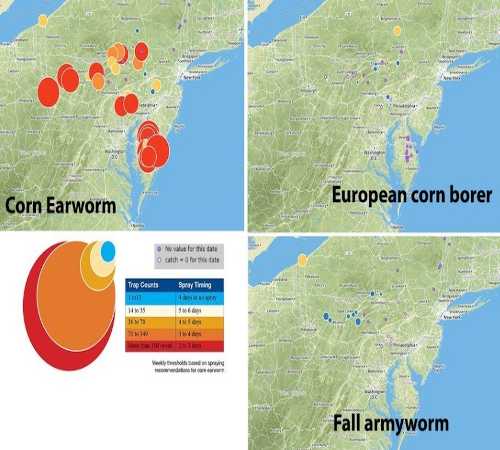
- CEW counts continue to be high. Circle color aligns with CEW thresholds; size is proportional to catch.
- ECB counts are low, but with an isolated spot in Susquehanna County, and last week in Union County.
- FAW is showing up in isolated hot spots, especially in Erie County, and less so in Indiana and Mifflin counties. FAW makes large, ragged feeding patterns.
7-day moving average: catch/nights trapping, divided by the number of nights with data, times 7. Weeks, where all the average-catch-per-night values are nulls, are treated as if no data exist for that week. Empty cell = no trap for that site. Bold text are sites above CEW threshold or hotspots for ECB or FAW. Italics suggest tighter spray intervals.
| County | Town/Farm | CEW | CEW | CEW | ECB | ECB | ECB | FAW | FAW | FAW |
|---|
| | | 5-Aug | 12-Aug | 19-Aug | 5-Aug | 12-Aug | 19-Aug | 5-Aug | 12-Aug | 19-Aug |
| Blair | Tyrone | 7 | 11 | 14 | 4 | 2 | 0 | 10 | 2 | 5 |
| Bucks | Bedminster | 3 | 5 | 30 | 0 | 0 | 0 | | | |
| Centre | Harner | 46 | 98 | 90 | 0 | 0 | 0 | 18 | 4 | 4 |
| Centre | Rock Springs | 18 | 68 | 30 | 0 | 0 | 0 | 5 | 1 | 5 |
| Clinton | Loganton | 1 | null | 24 | null | null | 0 | | | |
| Erie | Dudas Farm | 12 | 32 | 12 | | | | 7 | 3 | 8 |
| Erie | Mason | 20 | 9 | 30 | | | | 22 | 15 | 29 |
| Indiana | Brush Valley | 19 | 32 | 118 | | | | 2 | 0 | 6 |
| Indiana | Creekside | 40 | 76 | 136 | 0 | 0 | 0 | 12 | 8 | 13 |
| Juniata | Happy Breeze | 23 | 64 | null | 5 | 4 | null | 4 | 2 | null |
| Lackawanna | Ransom | 0 | null | null | 3 | null | null | | | |
| Lancaster | Landisville | 22 | 31 | 24 | 0 | 1 | 5 | 0 | 1 | 0 |
| Lancaster | Neffsville | 17 | 41 | 31 | 0 | 0 | 0 | 0 | 0 | 0 |
| Lancaster | New Danville | 25 | 82 | 85 | 0 | 0 | 1 | 0 | 0 | 0 |
| Lehigh | Germansville | null | 17 | 4 | null | 0 | 0 | null | 0 | 0 |
| Luzerne | Drums | 0 | 106 | 47 | 5 | 11 | 5 | 0 | 1 | 0 |
| Luzerne | Plains | 8 | 20 | 74 | 2 | 4 | 0 | | | |
| Lycoming | Linden | 3 | 45 | null | | | | 24 | 7 | null |
| Lycoming | Montoursville | 81 | 65 | null | | | | 2 | 1 | null |
| Lycoming | Muncy | 38 | 87 | null | | | | 6 | 3 | null |
| Mifflin | Streamside | 55 | 45 | 58 | 3 | 1 | 2 | 40 | 20 | 12 |
| Montgomery | Souderton | 7 | 20 | 7 | | | | | | |
| Montour | Washingtonville | 32 | 31 | null | 3 | 0 | null | | | |
| Schuylkill | Tower City | 0 | null | null | 1 | null | null | 0 | null | null |
| Susquehanna | LaRue Farm | null | 4 | 5 | null | 10 | 17 | | | |
| Union | Oberholtzer | 1 | 5 | 28 | 3 | 4 | 5 | | | |
| Union | Lewisburg | | | | 1 | 22 | 3 | | | |
| Washington | Venetia | 92 | 200 | 183 | | | | | | |
| York | York | 37 | 107 | 87 | 0 | 0 | 0 | 3 | 2 | 0 |
Thresholds
Reproductive (tassel/silk) and late vegetative corn attracts moths. Shorten spray schedules when populations increase. If CEW is not a problem, then consider ECB.
| Thresholds Based on CEW | Catch Per Week | Spray Frequency (Days) |
|---|
| Almost absent | 1–13 | 7+ |
| Very low | 14–35 | 5–6 |
| Low | 36–70 | 4–5 |
| Moderate | 71–349 | 3–4 |
| High | > 350 | 2–3 |
| Thresholds Based on ECB | Catch Per Week | Spray Frequency (Days) |
|---|
| Almost absent | < 14 | 7+ |
| Very low | 15–35 | 6 |
| Low | 36–70 | 5 |
| Moderate | > 70 | 4 |
Source : psu.edu