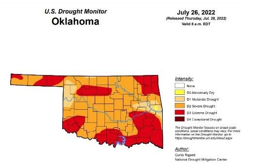
Drought conditions in Oklahoma have ramped up significantly since last week with percentage shifts upward in most categories of drought over 30 points and the majority near or at 100 percent.
According to the latest drought monitor, in Oklahoma, exceptional drought remains at zero, the same as last week.
Extreme drought or worse has increased almost 31 percentage points from last week’s 6.8 percent and is now at 37.4 percent.
Severe drought or worse has increased 34.6 percentage points from last week’s 57.5 percent and is now at 92.1 percent.
Moderate drought is now at 99.8 percent, up slightly from last week’s 99.6 percent.
100 percent of Oklahoma remains in abnormally dry or worse conditions, same as last week’s 100 percent.
The 6-10 day precipitation outlook map shows the majority of Oklahoma is leaning below a 40-50 percent chance of precipitation through August 6th.
To view the Oklahoma Drought map, click here.
According to the latest U.S. Drought Monitor Report, drought persisted across much of the West this week, while flash drought over parts of the Great Plains, Ozarks, and Mississippi Valley continued to intensify and cause agricultural problems. Short-term drought also expanded over parts of the Northeast this week, where deficits in short-term precipitation and streamflows mounted in some areas. Conditions locally improved in parts of the Southwest due to an influx of rainfall from the North American Monsoon. Farther east into the lower Great Plains and Midwest, localized heavy rainfall led to improvements, including severe flooding in the St. Louis Metro area, which previously had been experiencing abnormally dry conditions. In Alaska, moderate drought was mostly removed after recent rainfall improved conditions there.
In the Southern Plains, weather across the South this week was mostly hot and dry, with some notable exceptions. Heavier rain occurred in southern Louisiana and southern Mississippi, as well as eastern Tennessee. Very localized heavy rain fell from east-central Oklahoma into southwest Arkansas. Temperatures across the region were generally 2-8 degrees warmer than normal, with the warmest readings occurring in Oklahoma, Texas, northern Arkansas, and the western half of Tennessee. Flash drought conditions intensified further in central and northern Arkansas, central and eastern Oklahoma, and in spots in western Tennessee, northern Mississippi, northern Louisiana, and eastern and southern Texas. Crop failure and related problems are widespread in the part of the region experiencing flash drought, especially in northeast Texas, eastern and central Oklahoma, and northern Arkansas.
In the High Plains, with the exception of Colorado (which was mostly warmer than normal) and southern Kansas (which was 4-8 degrees warmer than normal), temperatures in the High Plains region this week were generally within 2-4 degrees of normal. Rainfall from the North American Monsoon occurred in parts of southern, central, and eastern Colorado, locally easing drought conditions in the eastern part of the state. Heavy rains in south-central and southwest South Dakota, and in southern Nebraska, northern Kansas, and east-central Kansas, led to locally improved drought and dryness conditions. Meanwhile, south of the heavier rains, flash drought continued to take hold in southern Kansas, where a combination of dry and hot weather worsened conditions. Extreme drought expanded in parts of southwest Nebraska, where short- and long-term precipitation deficits worsened conditions amid poor crop health. Drought also expanded in northeast Nebraska and southeast South Dakota, where soil moisture deficits continued to mount amid warm temperatures and dry weather. Extreme drought also developed in western Wyoming, where above-normal evaporative demand combined with short-term precipitation deficits to worsen conditions locally.
In the West, rainfall from the North American Monsoon over the last few weeks led to some improvements in the drought situation across Arizona and New Mexico, where precipitation deficits lessened. Rain also fell in parts of Nevada, Utah, and eastern California this week. Temperatures were mostly 2-6 degrees above normal in the West region, though scattered areas were within a couple degrees of normal. Precipitation deficit amounts lessened enough for some improvement to ongoing short- and long-term drought in central Montana. Elsewhere, widespread drought continued this week across a large portion of the region.
To view the Contiguous U.S. Drought Map, click here.
Click here to see more...