Considerable variation in soil texture, type and major factors within and across production fields affect crop production and significantly impact management strategies. Therefore, a uniform rate of input applications over the entire field can be costly and not maximize the benefits. Sensor-based and variable rate input applications, known as site-specific management, can improve farm profits, soil health and environmental quality.
Precision agriculture tools can address the variations in the production system to enhance plant growth and crop yield. In an ideal precision farming practice, applications would accurately utilize inputs' amount, timing and manner based on variabilities (management of a single plant). Soil properties, such as structure, texture, organic matter and electrical conductivity (EC), can determine the type/amount of inputs (fertilizer need, irrigation scheduling, seeding rate, seeding depth, etc.). Variable rate application (VRA) and site-specific management (SSM) are the methods that adjust the input applications according to the soil variations.
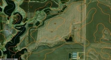
The USDA NRCS Web Soil Survey is a detailed report on the soils of an area featuring maps with soil boundaries, photos, descriptions, soil properties and feature tables. Courtesy: USDA NRCS
Whole-Field vs. Zone Management
So, what is the difference between whole-field management and zone management? Whole-field management treats the field as one unit with flat rates of inputs, while zone management allows the variable rate of inputs application to optimize the utilization of the input based on the needs. As a result, precision agriculture tools can help increase production, energy efficiency and improve environmental quality and profits. The first step to implement zone management is find and detect the variations that control yield and create different zones. The next step is to treat each zone individually. The precise application or treatment would be based on information associated with each zone individually. In a map-based, variable rate application system, the Global Positioning System (GPS) delineates management zones and computer interfaces with variability maps, and the VR applicator utilizes appropriate recommendations.
Creating the zones is based on the study of static, non-random and steady parameters (like variation in soil texture: clay, loam, sand, etc.). However, recorded plant response to soil variability, such as yield data, can be interpreted and become a reliable factor for creating zones. Each zone should be large enough that the applicator can technically and timely be responsive for changing the rates. Usually, creating three to five zones is enough. However, this number can change based on variability and the field size. There are several ways for creating the zones in a field, as mentioned below.
Creating Zones in a Field
Soil Electrical Conductivity (EC)
Soil EC describes the ability of a soil to transmit an electrical current and is expressed in milliSiemens per meter (mS/m). A soil electrical conductivity meter sends a known electrical current into soil and measures the soil particles' ability to transmit that current, stamped with a GPS coordination for a given field. Soil electrical conductivity measurement can be used successfully to quantify variations in soil texture and yield potential of production. Soil EC measurement, as one of the precision agriculture decision-making tools, can help growers to decide their nutrient management, seeding rate, seeding depth and irrigation scheduling. Soil EC measurement is one of the fastest, least-expensive methods to provide information about soil texture, cation exchange capacity (CEC), drainage conditions, organic matter level and salinity.
Yield Maps
Yield mapping is a technique in agriculture to analyze variables, such as crop yield and moisture content. A real-time yield monitoring system on a harvester records geo-referenced information about crop mass flow or volume, moisture and the area covered. This information further will be used to create yield maps.
Aerial Imagery or Bare Soil Image
Using airplanes or drones to create high-resolution images and by the image analyzing techniques, zones are created.
Soil Maps
Soil data is a key factor in fertilizer recommendations that are commonly derived from soil sample analyses collected the field. Two common methods for collecting soil samples based on smaller management zones are grid sampling and zone sampling. In grid sampling, a field is broken into equal square areas from which soil samples are collected. Smaller grid sizes provide a better representation of field variability. However, a higher sampling cost is associated with small grid sizes due to the number of samples. The second sampling method is zone sampling. In this method, zones are created to determine areas with similar soil properties before the soil sampling (i.e., soil texture, soil organic matter, soil electrical conductivity). Depending on the method used for creating zones and their size, zones can vary on how effectively they capture the variability in the field.
Web Soil Survey
The Web Soil Survey is a detailed report on the soils of an area provided by the U.S. Department of Agriculture Natural Resources Conservation Service (USDA NRCS). The soil survey has maps with soil boundaries and photos, descriptions, soil properties and features tables.
Multiple Methods
Any combination of the methods mentioned above.
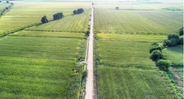
Zone management allows the application to optimize the utilization of the input and has the potential to decrease the overall use of chemicals, seed, water and other inputs. Courtesy: Canva
In Summary
Zone management allows the application to optimize the utilization of the input and has the potential to decrease the overall use of chemicals, seed, water and other inputs. Through site-specific management, inputs are managed on a smaller scale, enabling producers to address a field's variations precisely.
Source : sdstate.edu