Current status
The roller coaster ride of temperatures continues for Kansas. State-wide temperatures averaged 38.7 degrees F (Figure 1) or 2.7 degrees cooler-than-normal for the week ending on March 13th (Figure 2). The Northeastern Division had the largest departure from normal at 4.6 degrees F cooler-than-normal with an average temperature of 35.8 degrees F. The West Central Division had the least departure with an average of 38.9 degrees F, or 0.9 degrees cooler-than-normal. There was a wide swing between the warmest and coldest readings. The Southwest, South Central, and Central divisions all had a diurnal variation – the difference between the warmest and coldest temperatures -- of 65 degrees. The Northeast Division had the least range in temperatures with an average diurnal variation of 52 degrees. The warmest reading in the state was 78 degrees F reported at Hutchinson 4NE, Reno County, on the March 10. The coldest reading in the state was 0 degrees F reported at multiple locations across the state on the 7th and again on the 9th.
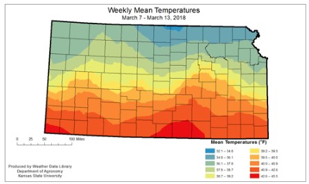
Figure 1. Weekly mean temperatures for Kansas during the week of March 7-13 via Cooperative Observer (COOP) and Kansas Mesonet.
Figure 2. Departure from weekly mean temperatures for Kansas during the week of March 7-13 via Cooperative Observer (COOP) and Kansas Mesonet.
Moisture was almost non-existent. The state-wide average was zero inches, or zero percent of normal. That is 0.45 inches below-normal for the period. No division averaged measurable precipitation. Of the combined monitoring stations: including NWS COOP, CoCoRaHS and Kansas Mesonet stations – a total of 510 stations – only 14 reported measurable precipitation. The greatest weekly total for the National Weather Service Cooperative Stations was 0.02 inches at Cottonwood Falls in Chase County. The highest weekly total at a Community Collaborative Rain Hail and Snow network station was 0.04 inches at Newton 6.5 WNW. For the Kansas Mesonet, the greatest total was 0.06 inches at Hiawatha, in Brown County. There were only trace amounts of snowfall during the week.
Figure 3. Weekly measured precipitation for Kansas during the week of March 7-13 via Cooperative Observer (COOP) and Kansas Mesonet.
Figure 4. Departure from normal weekly measured precipitation for Kansas during the week of March 7-13 via Cooperative Observer (COOP) and Kansas Mesonet.
Despite the cooler-than-normal temperatures, the continued dry weather resulted in drought expansion across the state (Figure 5). A small corner of northwest Kansas remains drought free (Figure 6). The portion of the state in extreme drought expanded slightly from last week to just over 19 percent, and areas in moderate and severe drought worsened. Exceptional drought remains in the southern parts of the state, expanding north from Oklahoma.
Figure 5. One week change in drought classifications from the Drought Monitor.
Click here to see more...