By Mary Knapp
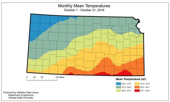
Temperatures in Kansas continued the warmer=-than-normal pattern through much of October. The statewide average temperature was 60.9 oF, or 5.6 degrees warmer than normal. This was the 8th warmest since 1896. The Northeast Division was closest to normal for the month. Its average was 59.8 oF, or 4.8 degrees warmer than normal. The division with the greatest departure was the Southwest Division where the average temperature was 62.3 oF or 6.7 degrees warmer than normal. There were 102 new daily record high temperatures set in the month; of those, 12 set new record highs for October. Ashland, in Clark County, had the highest reading for the month, with 102 oF reported on both the 17th and the 18th. In contrast, there were no new record low maximum temperatures or minimum temperatures set. There were 58 new record warm minimum temperatures set. The coldest temperature recorded for the month was 25 oF at Brewster 4W, Thomas County, on the 8th and Tribune 1W, Greeley County, on the 7th.
Statewide average rainfall for October was well below normal; however the distribution was quite skewed. The statewide average was 1.35 inches or 45 percent of normal. The western three divisions all averaged less than 10 percent of the normal October precipitation. The Northwest Division missed out on most of the rainfall. The divisional average was just 0.02 inches, or one percent of normal. The Southwest Division was the wettest of the western areas, and averaged just 0.14 inches of precipitation. That is just 9 percent of normal. In contrast, the Southeastern Division averaged 4.50 inches or 120 percent of normal. This October ranks as the 34th driest in the 122 years of record. The wettest October on record occurred in 1941, when the statewide average total was 5.99 inches. The driest October occurred in 1973 when the statewide average was just 0.02 inches. Despite the dry pattern there were 35 new record daily rainfall totals. The greatest 24-hour total recorded at a CoCoRaHS station was 6.69 inches at Beaumont 6.6 SSW, Butler County, on the 7th. The greatest 24-hour report for a National Weather Service station was 6.44 inches at Parsons Tri City AP, Labette County, on the 6th. The greatest monthly totals: 9.91 inches at Independence, Montgomery County (NWS) and 7.27 inches at Beaumont 6.6 SSW, Butler County (CoCoRaHS)
Severe weather was also a factor with an unusual tornado outbreak on the 7th of October. There were 16 tornadoes reported during the event, with storms in Allen, Clay, Cowley, Dickinson, and Labette counties. Fortunately there were no deaths or injuries reported with the storms. There were a total of 33 hail reports and 17 damaging wind reports in the month.
Above-normal temperatures coupled with below-normal precipitation resulted in the return of moderate drought in southwest Kansas, with an expansion of abnormally dry conditions across much of the western divisions. The continued dry pattern, coupled with the outlook for warmer-than-normal conditions in November, is likely to result in further expansion of both categories.
1. Departure from 1981-2010 normal value
2. State Highest temperature: 102 oF at Ashland, Clark County, on the 17th.
3. State Lowest temperature: 25 oF at Brewster 4W, Thomas County, on the 8th and Tribune 1W, Greeley County, on the 7th.
4. Greatest 24hr: 6.44 inches at Parsons Tri City AP, Labette County, on the 6th (NWS); 6.69 inches at Beaumont 6.6 SSW, Butler County, on the 7th (CoCoRaHS).
Source: ksu.edu