By Craig Sheaffer and Nathan Drewitz
Planting alfalfa alone or in a mixture with grasses in late summer is recommended because the potential for optimal air temperatures and soil moisture for establishment is good. In addition, there is much less competition with annual weeds compared to spring seedings; therefore’ herbicide use is seldom needed. Typical recommended seeding dates for central and southern Minnesota range from August 15th to September 1st.
Drought effects on seedling survival
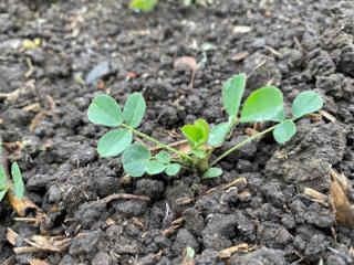
Figure 1. An 8-week-old alfalfa seedling with four fully
developed trifoliolate leaves and a unifoliolate leaf. Seedling
is undergoing contractile growth leading to formation of a
submerged crown. It has a high probability of successfully
overwintering.
Drought during late August and September will delay germination until favorable soil moisture is available. To germinate, alfalfa seeds must absorb over 100% of their weight in water. Delayed emergence caused by dry soils increases the risk of establishment failure through winter injury because seedlings do not have time to adequately develop crowns and roots. Plants with a high probability of survival will have at least four trifoliolate leaves (Figure 1).
If adequate moisture is available, alfalfa seeds continue to germinate throughout the fall and even during winter. Alfalfa can germinate at temperatures as low as 32 F although it can take 2 weeks for germination. Unfortunately, seeds that germinate after mid-September have little chance of developing into plants that survive till spring. Growers can expect significant yield reductions from surviving plants.
What could change this prediction? An early and continuous snow cover of 6 inches or more that lasts until spring may result in greater seedling survival than expected. However, even then, seedlings with small root systems would have to withstand spring thawing and freezing cycles that can promote heaving of roots.
Time required for seedling growth
Seed germination and seedling emergence by early September at near optimum temperatures of 65-75 F will allow for 8 or more weeks of growth before a significant killing frost. In an earlier Crop News, we showed that alfalfa seedlings had good tolerance to air temperatures as low as 24F. For much of central and southern MN, these temperatures are not typically reached until early November.
With normal late summer temperatures, seedling emergence is complete within 2-7 days and the unifoliolate stage is reached in about 2 weeks. Contractile growth, which pulls the cotyledonary and unifoliolate nodes below the soil surface, and below ground crown formation begins as early as the unifoliolate leaf stage and continues until about 8-10 weeks after seedling emergence. This early growth protects the new crown and crown buds from low winter temperatures.
In addition to contractile growth, time is required for the development of 3-4 trifoliolate leaves, which generate carbohydrates that are stored in the roots. Simple sugars and starch are required for survival of the plants over winter.
Perennial grasses
Perennial grasses seeded alone or with alfalfa have an advantage in tolerating late emergence because they have hypogeal emergence. In hypogeal emergence, the seed and growing point stay below ground and are protected from winter injury by the soil. Perennial grasses, like orchardgrass, perennial ryegrass, and meadow fescue, still require the development of 3-4 leaves to reliably survive the winter.
Source : umn.edu