Mid-May is here which means it is time to update the South Dakota (SD) Grassland Productivity Maps with conditions changing slightly since the last forage update on May 1.
Produced through the SD Natural Resources Conservation Service (NRCS) Drought Tool, these maps will be updated approximately every 15 days utilizing a two-year weighted average of precipitation data to determine a percent of normal production calculation incorporating historical clipping data from across the state. Forage maps relate to grassland forage production and not cropland as the maps will not predict forage quality. These reports will subside starting July 1.
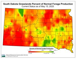
“The ‘current’ map compares and averages precipitation from the last two years — this map shows that we have received below average precipitation throughout much of SD. An open winter, dry fall, and fairly dry spring have not set up our forages for a high-producing year. The ‘forecasted’ map shows what peak forage production will look like if the remaining time between now and July 1 has average precipitation,” says State Rangeland Specialist, Emily Rohrer.
Although the National Weather Service’s 30 and 90-day projected outlooks show a greater chance for below normal precipitation, the good news is we did get some nice rains the past few days that will alleviate some of the low moisture woes we have been feeling and give our planted crops and forages a much-needed drink.
Source : usda.gov