By Nick Paulson and Gary Schnitkey
The USDA’s harvest season estimates were for 2024 US corn and soybean yields to be above trend because of good to excellent conditions throughout most of the growing season. Those yield estimates were revised down following the 2024 harvest season, with final U.S. yields coming in slightly below trend for both corn and soybeans. While early yield estimates for Illinois were also revised down, 2024 corn and soybean yields ended above trend, extending a twelve-year run of excellent corn and soybean yield performance in Illinois. Since the 2012 drought, Illinois yields have fallen below trend for both crops in just one year, the delayed planting year of 2019.
Corn Yields in 2024
The USDA’s final US corn yield estimate for 2024 was 179.3 bushels per acre, roughly 1 bushel below the trend yield for US corn. Earlier corn yield estimates ranged from 183.8 bu/acre (October) to 183.1 bushels per acre (August and November).
The final 2024 Illinois corn yield of 217 bushels per acre also came in below harvest-season projections ranging between 222 to 225 bushels per acre. Still, the 217 final yield was about 10 bushels (4.6%) above trend. As shown in Figure 1, the 2024 yield continued a twelve-year run of excellent corn yield performance in Illinois. Since the 2012 drought, when yields were significantly below trend levels, the state-average corn yield in Illinois has fallen below trend in just one year – 2019, when an extremely wet spring resulted in higher than normal prevent plant acres, a late harvest, and relatively poor yield performance.
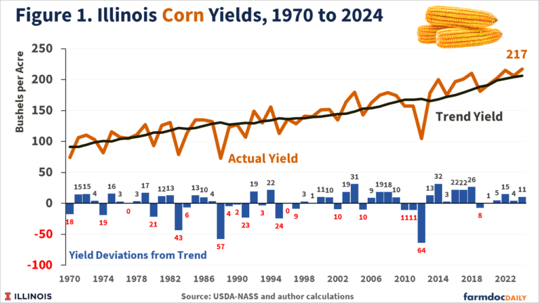
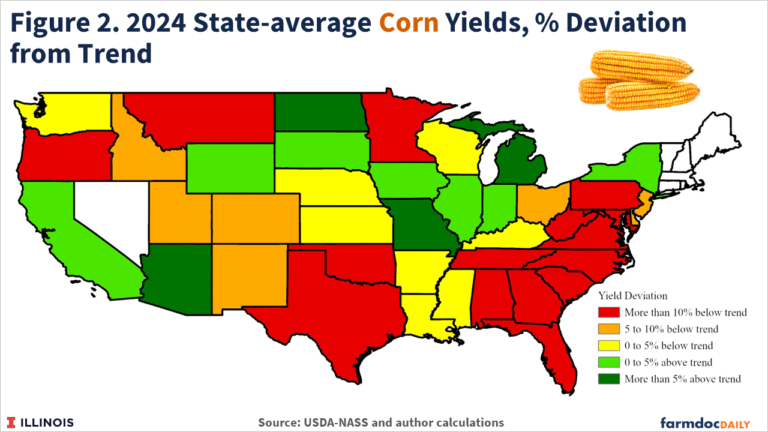
Figure 2 maps 2024 yield performance in all US states for which USDA’s National Ag Statistics Service (NASS) provides corn yields. In the Midwest, corn yields exceeded trends by more than 5% in North Dakota, Missouri, and Michigan. Corn yields were less than 5% above trend in the Midwestern states of South Dakota, Iowa, Illinois, and Indiana. Major corn-producing states with average corn yields below trend in 2024 included Kansas, Kentucky, Minnesota, Nebraska, Ohio, Wisconsin, and Texas. While outside the major production region for corn, states to the east and south of Ohio experienced yields below trend levels.
Soybean Yields in 2024
Final soybean yields for the US and Illinois were also below harvest-season estimates. The 2024 US soybean yield of 50.7 bushels per acre was nearly 2 bushels below trend. Earlier estimates ranged from 51.7 (November) to 53.2 (August and September) bushels per acre.
The final Illinois soybean yield of 64 bushels per acre was below the 65 to 67 bushel range of earlier estimates but was still above trend, albeit at less than 1 bushel per acre. As shown in Figure 3, Illinois soybean yields have also been on a run of excellent performance since the 2012 drought, with yields exceeding the trend in all but 1 of the last 12 years. The exception, like corn, was in 2019.
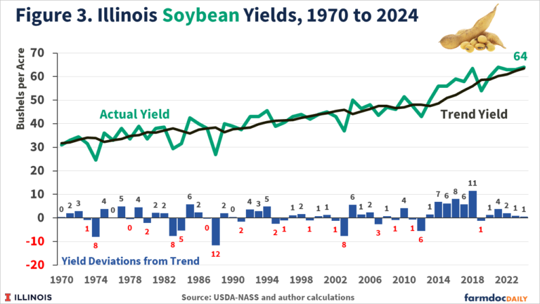
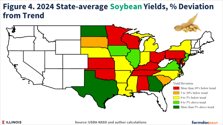
Figure 4 maps soybean yield performance in 2024 relative to trends for all US states with a yield estimate reported by NASS. Soybean yields exceeded trends by more than 5% in North Dakota, Texas, and Georgia. Yields exceeded trend by less than 5% in Iowa and Illinois, as well as in the smaller-production states of Virginia and Delaware. Soybean yields were more than 10% below trend in the Midwestern states of Minnesota, Wisconsin, Ohio, Kansas, and Kentucky. Smaller average yield losses relative to trend levels were seen in Arkansas, Indiana, Michigan, Mississippi, Missouri, and South Dakota.
Summary
Good to excellent conditions in major production regions, including Illinois, resulted in harvest-season yield projections for US corn and soybean yields that were above trend levels. Yield estimates were however revised down during and following harvest. Final yield estimates for the US were slightly below trend levels for corn and soybeans. Corn and soybean yield experience varied by state, with average state-level yields both above and below trend in 2024. While yield estimates for Illinois were also revised down throughout the fall, final yield numbers were above trend levels, continuing a 12-year streak of excellent yields in Illinois dating back to the 2012 drought.
Source : illinois.edu