By Rebecca Ozeran
Several months ago, I got a question about weeds in an irrigated pasture. The mystery plants were slowly but surely taking over a significant proportion of the pasture, and the owner asked me to visit the property to identify the plants and options to control them.
A brief detour in my story, for important context: Before I visit any property, I map it so I know how to get to their entrance road – which is often a dirt road that doesn't show up correctly on the standard view in Google Maps. To make sure I know what I'm looking for, I switch to satellite view to find the necessary roads.
Because I'm typically looking for roads and not looking at landscapes, I got a pleasant surprise when mapping this property. I could actually see their weed problem from above.
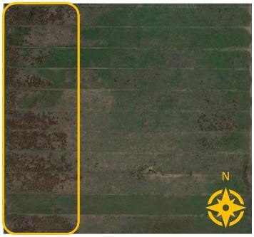
Image 1: a portion of the property as seen on Google Maps. Circled in yellow is the densest area of the weedy infestation.
Although the level of detail isn't sufficient to identify the species, dark patches of plants are evident in the satellite image. Interestingly, the patches are mostly clustered on the western end of the property. I began to wonder if the issue was related to the landscape itself, or the irrigation pattern.
When I arrived at the property, the plants became obvious: rushes (Juncus spp.). This explained a lot. Although some species of rushes are native to California, rushes are completely unpalatable to livestock, and therefore considered a weedy plant in grazed settings. Moreover, rushes are water-loving species. (I've been told, “they like to keep their feet wet.”) This supported my hypothesis that the landscape and irrigation pattern were contributing to the infestation.
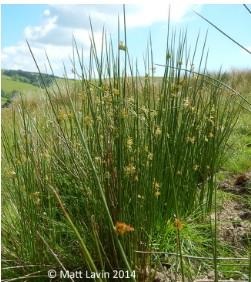
Image 2: Juncus effusus, also called soft rush.
The manager told me that the pasture was flood irrigated from east to west. Considering the highest densities of rushes were in the west, we guessed that water was pooling in that area due to over-irrigation. Of course, not every check (section of pasture irrigated at one time) had the same density of rushes. Variable micro-topography across checks may have influenced the speed of water flow from east to west. Tiny dips and bumps along a check would impact how much water infiltrated in the east versus the west. Indeed, at the satellite image scale, the check second from the bottom has no visible rushes.
We discussed treatment options and the need to re-seed desired forages regardless of the treatment. Considering the pattern of infestation which was visible on site and via satellite, we also agreed that the best prevention measure will be to reevaluate and possibly reduce the amount of irrigation water applied to each check. Reducing the saturation of the west-end soils will help to encourage more desired forage species over rushes.
For me, this experience highlighted the value of satellite imagery as a quick tool to visualize landscape-level trends. Although they can't identify weeds for us, satellite images do show large-scale patterns.
Next time you are confronted with a large weedy patch, check out the view from a different perspective – it might help!
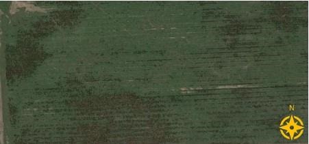
Image 3: Many irrigated pastures exhibit similar dark clusters on Google Maps. This unrelated property also seems to support rushes on the west end and in their southern checks. They may benefit from reevaluating their irrigation, too!
Source : ucanr.edu