By Bradley Miller, Zach Clemens
While seasonal weather can be the difference between a good and a bad harvest, it is the soil that moderates the long-term productivity of a field. The inherent properties of soils are vital to know when it comes to management practices on any agricultural landscape.
The state of Iowa has the agricultural economy that it does largely because of its soils. Iowa relies on soil for so many different things, the list can be overwhelming at times and includes crop production, water management, and land valuation.
Iowa State University researchers are working to update Iowa’s soil survey, which was completed about 30 years ago, with small tweaks since then. Those original maps were produced by the Cooperative Soil Survey, which was a partnership between Iowa State University and the United States Department of Agriculture’s Natural Resources Conservation Service. The maps were compiled county by county and each took about four years to complete.
The existing soil maps were meant to give a general idea of the soil resources, but as we get into precision agriculture, a lot of farmers—because they don’t have a better resource—are using these maps to decide on their management zones within the field, even though the creators of these maps never intended them for that.
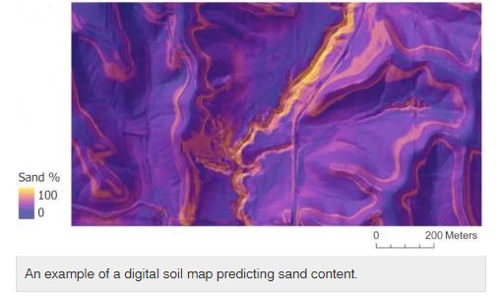
A statistically-based approach
What we need is higher spatial detail and a more statistically-based approach in predicting soil properties. Algorithms are being developed to automatically classify parts of landscapes with different soil properties. Every landscape has some unique characteristics that need to be accounted for, and that is done through machine learning.
An algorithm recognizes patterns in these landscape characteristics and uses those patterns to make predictions for areas without soil samples. Different technologies used to gather data are being input into the algorithm to increase consistency and accuracy of the maps.
Different sources of remotely sensed information, from an airplane or satellite platform, are stacked together with many potential covariates, or predictors. This means obtaining continuous coverage of data that is expected to covary with different soil properties. The difference from the traditional soil survey methods is the large quantity of covariates and the complex, quantitative models built by machine learning.
Covariates are collected in two different ways. The first is terrain analysis. This starts with detailed elevation data that comes from an airplane equipped with LIDAR, (Light Detection and Ranging). This measures the rise and fall of the landscape and records the elevation information by shooting a laser from the plane to the ground and recording the time it takes to bounce back. The elevation data is then analyzed for the different landscape aspects that influence environmental conditions, such as water flow.
The second method is collecting spectral information with satellites. The whole electromagnetic spectrum, both light seen by the human eye and light that can’t be seen is collected. Healthy vegetation on a landscape is directly related to the plant’s root system in the soil, thus being able to infer soil characteristics based on what it happening above ground. The big difference with the previous maps is there is now this big, new data source gained via satellite information, LIDAR information and machine learning that enhances the spatial detail of soils.
Research is still underway on finding the best covariates to use and the most appropriate machine learning algorithm to find complex patterns. While the full completion of this project relies on funding, the first version of an interactive web map for the public should be made available by the end of 2020, which will also be made available for download for GIS professionals.
Source : iastate.edu