Farms.com Home   News

How to Distinguish Flooding Injury from Phytophthora or Pythium Root Rot in Soybeans

By Anne Dorrance

Roots will have a "rat-tail" appearance following flood injury

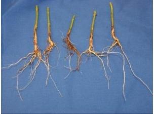
Figure 1. Roots will have a "rat-tail" appearance following flood injury

Flooding injury occurs when soils are saturated for several days and anoxia develops.  The roots are killed, as are the nodules that are home to the nitrogen fixing bacteria. The field has an “interesting’ smell but the key symptoms of this injury are on the roots. Dig up a few plants – if it is flooding injury the outside of the root – the epidermis will be easily pulled off the root leaving the white center – looks like rat tails (Figure 1). In addition, the nodules will be gray and easily crushed.

For Phytophthora stem rot – for those cultivars with low to moderate partial resistance ratings we will begin to see stem rot 5 to 10 days after the heaviest rains. On soybeans, a chocolate brown canker (Figure 2) will develop, the plants will turn yellow, wilt and die. Cultivars with low ratings may lose as much as 50% of the stand.  Where soils have been saturated but not submerged – this is a great year to check on those ratings.

Saturated soils promote infection from many of the watermolds – from our data over the past 15 years, there are more than 30 different species that cause root rots. If the soybean plants become infected with one of more of the watermolds – the roots will turn tan to dark brown and become soft.

Chocolate brown stem cankers are a symptom of Phytophthora stem rot

Figure 2. Chocolate brown stem cankers are a symptom of Phytophthora stem rot

Management during this season – this is time to be proactive for next year based on the data that you now have. Drainage is key to limit the losses from flooding, Phytophthora & watermolds. 

  • Documenting where the ponding occurred combined with the yield maps will help to pin point these areas to fix in the future. 
  • Does your resistance package work to Phytophthora – if the partial resistance levels are high then you should not see stem rot develop on these soybeans.  Note every company has a different scale (i.e. 1 to 9 or a 9 to 1 scale) so read the fine print.

If left alone and not stressed more, many fields may recover (Figure 3). New roots will begin to form as soon as they can breathe again, new nodules will form and the plants will “catch-up”. I’ve had plants grow new roots during the time they were shipped in the mail to me.

Scout for root regrowth following flooding injury

Figure 3. Scout for root regrowth following flooding injury

Source : osu.edu

Trending Video

Spring 2026 weather outlook for Wisconsin; What an early-arriving El Niño could mean

Video: Spring 2026 weather outlook for Wisconsin; What an early-arriving El Niño could mean

Northeast Wisconsin is a small corner of the world, but our weather is still affected by what happens across the globe.

That includes in the equatorial Pacific, where changes between El Niño and La Niña play a role in the weather here -- and boy, have there been some abrupt changes as of late.

El Niño and La Niña are the two phases of what is collectively known as the El Niño Southern Oscillation, or ENSO for short. These are the swings back and forth from unusually warm to unusually cold sea surface temperatures in the Pacific Ocean along the equator.

Since this past September, we have been in a weak La Niña, which means water temperatures near the Eastern Pacific equator have been cooler than usual. That's where we're at right now.

Even last fall, the long-term outlook suggested a return to neutral conditions by spring and potentially El Niño conditions by summer.

But there are some signs this may be happening faster than usual, which could accelerate the onset of El Niño.

Over the last few weeks, unusually strong bursts of westerly winds farther west in the Pacific -- where sea surface temperatures are warmer than average -- have been observed. There is a chance that this could accelerate the warming of those eastern Pacific waters and potentially push us into El Niño sooner than usual.

If we do enter El Nino by spring -- which we'll define as the period of March, April and May -- there are some long-term correlations with our weather here in Northeast Wisconsin.

Looking at a map of anomalously warm weather, most of the upper Great Lakes doesn't show a strong correlation, but in general, the northern tiers of the United States do tend to lean to that direction.

The stronger correlation is with precipitation. El Niño conditions in spring have historically come with a higher risk of very dry weather over that time frame, so this will definitely be a transition we'll have to watch closely as we move out of winter.