Millions of people around the world face hunger every day, and unfortunately, the COVID-19 pandemic is expected to make the issue of food security even worse. Satellites are helping to alleviate the situation by providing crucial information to monitor crop growth and harvesting from space.
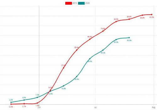
The graph shows the cumulated area of 2020 harvesting relative to 2019.
A recent report from the World Food Programme forecasts that the COVID-19 pandemic could push over 130 million additional people into chronic hunger by the end of 2020. The pandemic has caused numerous problems and uncertainties along the food supply chain such as limited labour, transport, cross-border trade and the availability of produce.
It is important to understand how the pandemic is disrupting the growth and harvest of staple crops as well as the food supply chain, which can be affected by various factors such as shortages of fertiliser, a lack of labour and issues associated with national export policies. These limitations create uncertainty in food markets and, therefore, the availability of food in the future.
Satellite monitoring tools are useful as they can provide information on planting and harvesting for key food and agriculture commodities.
NASA, ESA and the Japanese Aerospace Exploration Agency (JAXA) worked recently to create the COVID-19 Earth Observation Dashboard, a platform that combines a wealth of satellite data to monitor the impacts of COVID-19 worldwide—including agricultural production.
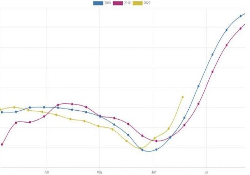
Time-series changes of the normalized difference vegetation index (NDVI) over Sacramento, California, US. NDVI can be used to indicate rice growing conditions
A recent study, featured on the dashboard, analysed the harvests of winter cereals over Spain. In Spain, winter cereals are cultivated over almost two million hectares, mainly in the regions of Castilla and León, Andalucia, Castilla-la-Mancha and Aragón. Thanks to satellite data, the harvests can be monitored in near-real time, at parcel-level over the entire country.
Scientists from the Université catholique de Louvain in Belgium used data from the Copernicus Sentinel-1 and Sentinel-2 missions and the US Landsat-8 mission together with machine learning to monitor crops on a weekly basis. Comparing the data with that of last year, they found that the 2020 harvesting season started in mid-June, which is later than the average crop calendar for winter cereals in Spain.
Click here to see more...