By Dr. Mark Licht and Zach Clemens
Choosing a corn seeding rate is as much art as it is science because soil conditions and seed quality can greatly affect the outcome. The goal is to choose a seeding rate that produces an economical optimal yield as opposed to the maximum yield. A seeding rate has to factor in seed quality, weather, and genetics to achieve a desired harvest plant population. This is more important now than ever because seed costs have risen over the last two decades. Typically, the optimal rate will be 3,000 to 5,000 seeds per acre less than the rate at which maximum yield is attained.
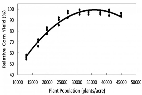
Figure 1. Maximum corn plant population tends to be near 35,000 plants/acre. To achieve a desired plant population; seed germination, field conditions and other factors need to be accounted for in determining an appropriate seeding rate (Guide to Corn Planting).
While attempting to optimize corn seeding rates normally means reducing seeding rates, there are reasons for increasing seeding rates to account for poor quality seed or harsh environments that lend themselves to greater seed and seedling mortality. Seed quality, particularly seed germination percentage, can influence the optimal seeding rate. When seed germination rates are below 90% the seeding rate should definitely be accounted for with a higher seeding rate.
Keep in mind that seed tag germination rates are based on a warm germination test. A warm germination test is essentially like planting the seed into an ideal environment at 77oF. How often is corn planted at 77oF? Rarely, I hope. If time and resources allow, a cold germination or cold saturated germination test may be a better indication of what to expect in the field. Both of these have germination start at 50 oF then move to 77 oF. Both of these tests would give a better indicator of seed germination and vigor compared to the warm germination test. And it would also allow for better seeding rate adjustments.
Additionally, increasing seeding rates may be justified if planting into cooler or wetter conditions when those conditions—although this is looking less probable for 2021—are less than ideal for germination and/or the seed is at higher risk for seedling pathogen infection.
And finally, the choice of hybrid should also be considered when determining the seeding rate. Hybrid genetics influence optimal seeding rates. Some hybrids perform best as low or moderate seeding rates while others perform better at high seeding rates. Consult with a seed agronomist to get a rough idea of the seeding rate suitable for the genetics you have chosen.
Source : iastate.edu