By Martin Käßler and Fraunhofer-Gesellschaft
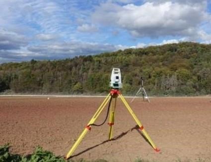
Digitization of the experi-mental field, with the measuring equipment in the foreground.
Crop diseases threaten yields in the field. Pests and parasitic weeds cause high crop losses of up to 30 percent every year. In the FarmerSpace project, the Fraunhofer Institute for Optronics, System Technologies and Image Exploitation IOSB in Ilmenau is working together with partners to investigate the use of digital technologies for crop protection. The aim is to detect leaf diseases and the spread of weeds at an early stage and to initiate targeted protective measures using sensors, robotics and data-driven solutions.
Targeted crop protection is critical in agriculture. It ensures that plants are protected from diseases, pests and weeds. A healthy supply of nutrients to wheat, corn and the like influences the quality of the food and prevents crop losses. In the FarmerSpace digital experimental field, the project partners are exploring the potential of digital technologies to detect crop diseases at the right time and place in the field. The platform for practical experiments offers players from research, practice and industry the opportunity to test sensor and data transmission systems, radio sensor networks, optical and machine-supported sensors, drone technology, robotics and machine learning methods in the fight against crop parasites. The project is being carried out by four partners: the institute branch Applied Systems Technology AST of Fraunhofer IOSB-AST, the Institute for Sugar Beet Research at the University of Göttingen, the Section of Agricultural Engineering at the University of Göttingen and the Lower Saxony Chamber of Agriculture. The German Federal Ministry of Food and Agriculture BMEL is funding the project, which will run from February 2020 to February 2023. The focus is on early detection and control of weeds and leaf diseases in sugar beet and spring wheat, which were sown specifically for research purposes in a trial field near Göttingen. While weed management is the focus in the spring, work in the summer concentrates on leaf diseases.
Digital survey of the field
As a first step, the research team at Fraunhofer IOSB-AST created a 3D model of the field, which serves as a reference model for the project partners. The surface of the five-hectare experimental field was surveyed using a laser scanner and GPS positioning system. This took two days, while the survey using drone technology took only 20 minutes. "However, the time factor alone is not decisive. Primarily, we want to find out which method provides more precise geodata. For this purpose, we also used camera recordings of robots driving over the field. The evaluation of the results, however, is not yet available," explains André Weiskopf, a scientist at Fraunhofer IOSB-AST. The evaluation is intended to provide information not only on accuracy, but also on practical criteria such as measurement, processing and evaluation time, area capacity and associated costs.
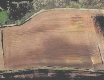
2D derivation of the laser scanner point cloud of the field.
The goal of digitally surveying a field is, on the one hand, to obtain more precise information about the density of the crop stand. On the other hand, it is important to find out when and where a disease infects the crop through viruses, fungi, aphids or other pests, and which measure the farmer can best use to control it. The key, then, is to apply targeted crop protection measures at the right time and limit them locally to the field area where they are needed. This can help reduce the use of crop protection products, thus reducing costs and time. "For example, if the weevil only attacks ten square meters of the entire field, the farmer can disregard the remaining area. In this way, the groundwater is less polluted," continues Weiskopf. For the Bremen Water Protection Ordinance stipulates that minimum distances must be maintained from flowing bodies of water. Farmers are not allowed to spray pesticides everywhere. "The terrain angle is an important parameter related to this," explains Norbert Fränzel, a colleague of Weiskopf at Fraunhofer IOSB-AST. "The previous terrain maps do not provide such accurate values in this regard. We hope to obtain more precise data and terrain models by digitizing the field."
Click here to see more...