By Aaron Wilson
Summary
After a very brief cool down the third week of September, summer-like weather has gripped the Buckeye State until this past Saturday. Most stations across Ohio have recorded their warmest October to date (1895-2021). Rainfall has been plentiful for some as well (Figure 1), especially across northwest Ohio, where locations have received 3-5 inches (200-300% of normal). Counties across central Ohio have been a bit drier. The strong cold front that swept through Friday night and dropped temperatures back closer to seasonal norms sparked several tornadoes across the state as well. The most significant (EF2- 115 mph winds) occurred near South Salem in Ross County. The chilly weather also brought the first reports of frost to some locations.
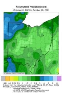
Figure 1). Accumulated precipitation for October 1-18, 2021. Figure courtesy of the Midwestern Regional Climate Center (https://mrcc.purdue.edu/).
Forecast
Strong high pressure and fair weather will remain in control through Wednesday. Highs will reach the upper-60s to mid-70s Tuesday and Wednesday, with overnight lows in the 40s. A fast moving cold front will increase the threat of showers for Wednesday night through Thursday night. Behind this front, breezy, cooler, and drier conditions will move back into the state. Highs this weekend will only reach the 50s and 60s, with frost possible and lows in the mid-30s to mid-40s.
Cannot rule out a few low-lying valleys reaching the freezing mark. Another round of showers could enter the region early next week as well. The Weather Prediction Center is currently predicting up to 0.50” of rain over the next 7 days (Figure 2).
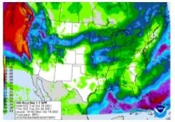
Figure 2). Precipitation forecast from the Weather Prediction Center for 8p Monday Oct 19 – 8p Monday Oct 26.
The Climate Prediction Center’s 6–10-day outlook for the period of October 24-28, 2021 and the 16-Day Rainfall Outlook from NOAA/NWS/Ohio River Forecast Center indicate temperatures and precipitation are leaning above average (Figure 3). Climate averages for this period include a high temperature range of 61-64°F, a low temperature range of 41-44°F, and average rainfall of 0.60-0.80 inches.
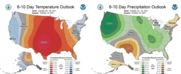
Figure 3) Climate Prediction Center 6-10 Day Outlook valid for October 24-28, 2021, for left) temperatures and right) precipitation. Colors represent the probability of below, normal, or above normal conditions.
Source : osu.edu