Farms.com Home   News

U.S. Soybean Crushings Steady in August

By Rob Hatchett
 
The National Oilseed Processor Association (NOPA) issued August soybean crush and stocks data on Monday, September 16. According to the data, NOPA member soybean processing was slightly lower from July but set another record for the month at 4.574 million tonnes. Cumulative October-August NOPA crush is now running 0.8% above last year. This points to another likely increase for the soybean crush will be coming from the U.S. Department of Agriculture (USDA) in the October World Agricultural Supply and Demand Estimates (WASDE).
 
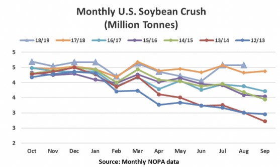
According to analysts’ expectations published by Reuters, the trade was looking for crush to come in near 4.409 million tonnes with the highest guess slightly above the actual at 4.599 million tonnes. While the trade was looking for a modest setback in processing as many analysts believed that July processing surged to make up for earlier unplanned downtime, August was expected to see a seasonal slowdown in processing as slipping crush margins and annual maintenance were seen as reducing run rates.
 
 
Click here to see more...

Trending Video

Spring 2026 weather outlook for Wisconsin; What an early-arriving El Niño could mean

Video: Spring 2026 weather outlook for Wisconsin; What an early-arriving El Niño could mean

Northeast Wisconsin is a small corner of the world, but our weather is still affected by what happens across the globe.

That includes in the equatorial Pacific, where changes between El Niño and La Niña play a role in the weather here -- and boy, have there been some abrupt changes as of late.

El Niño and La Niña are the two phases of what is collectively known as the El Niño Southern Oscillation, or ENSO for short. These are the swings back and forth from unusually warm to unusually cold sea surface temperatures in the Pacific Ocean along the equator.

Since this past September, we have been in a weak La Niña, which means water temperatures near the Eastern Pacific equator have been cooler than usual. That's where we're at right now.

Even last fall, the long-term outlook suggested a return to neutral conditions by spring and potentially El Niño conditions by summer.

But there are some signs this may be happening faster than usual, which could accelerate the onset of El Niño.

Over the last few weeks, unusually strong bursts of westerly winds farther west in the Pacific -- where sea surface temperatures are warmer than average -- have been observed. There is a chance that this could accelerate the warming of those eastern Pacific waters and potentially push us into El Niño sooner than usual.

If we do enter El Nino by spring -- which we'll define as the period of March, April and May -- there are some long-term correlations with our weather here in Northeast Wisconsin.

Looking at a map of anomalously warm weather, most of the upper Great Lakes doesn't show a strong correlation, but in general, the northern tiers of the United States do tend to lean to that direction.

The stronger correlation is with precipitation. El Niño conditions in spring have historically come with a higher risk of very dry weather over that time frame, so this will definitely be a transition we'll have to watch closely as we move out of winter.