By Aaron Wilson
Summary
Climatological summer (June-August) has come to an end and all eyes are now on harvest season. Overall, the summer of 2022 was average temperaturewise, with most of state seeing near to above average precipitation. The driest areas occurred over west central and northeast Ohio.
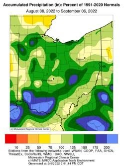
Figure 1). Percent of normal precipitation for the period August 8 – September 6, 2022. Figure courtesy of the Midwestern Regional Climate Center
Over the last 30 days, precipitation has been plentiful for much of the state, running more than 200% of normal across countes near the Ohio River (Figure 1). CoCoRaHS observations for the month show numerous sites in central and southwest Ohio coming in with 6-9 inches of rain, while locations in Darke, Shelby, and Miami Counties have only picked up 2 inches over the last 30 days. This wet pattern has kept extreme heat in check, with temperatures running about average for August. For the latest up-to-date conditions, seasonal outlooks, and monthly climate summaries, please visit the State Climate Office of Ohio.
Forecast
The slow moving frontal boundary that kept heavy downpours scattered across the region this past weekend, will start to move to the east on Wednesday. Improving conditions are expected for Thursday and Friday, with plenty of sunshine and highs in the mid 70s to low 80s across the state. The next cold front is expected to move into the area this weekend, bringing with it scattered showers and storms. The Weather Prediction Center is forecasting 0.25-1.0 inch of rain over the next 7 days (Figure 2).
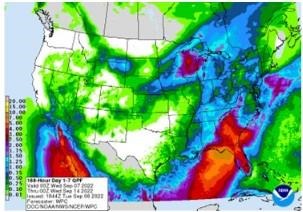
Figure 2). Precipitation forecast from the Weather Prediction Center for 8pm Tuesday September 6 – 8pm Tuesday September 14, 2022.
The Climate Prediction Center’s 6–10-day outlook for the period of September 12-16, 2022 and the 16-Day Rainfall Outlook from NOAA/NWS/Ohio River Forecast Center show near to below average temperatures and near average precipitation are expected (Figure 3). Climate averages include a high-temperature range of 77-81°F, a low-temperature range of 56-60°F, and average weekly total precipitation of 0.70-0.85 inches.
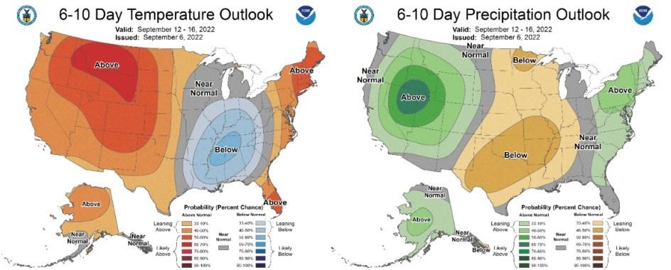
Figure 3) Climate Prediction Center 6-10 Day Outlook valid for September 12 – 16, 2022, for left) temperatures and right) precipitation. Colors represent the probability of below, normal, or above normal conditions.
Source : osu.edu